In Wrangell-St Elias National Park, a trip along the McCarthy Road offers unparalleled views and a deep understanding of Alaska’s history. It connects Chitina with McCarthy over a 60-mile scenic route. After waking up at 4 am, we headed straight for McCarthy Road. McCarthy Road offers a true Alaskan experience. Remember that safety precautions should be taken while driving. In McCarthy’s otherworldly setting, there’s a lot to discover.
This post may contain affiliate links, meaning if you purchase something through one of these links, we may earn a small commission at no extra cost to you! Read the full disclosure policy here.

Table of Contents
Unveiling the Exquisite Wonders of Driving the Scenic McCarthy Road in Wrangell-St. Elias
In Wrangell-St Elias National Park, the opportunities for exploration and adventure are endless. It is the largest national park in the United States, covering around 13.2 million acres. The park is home to some of the tallest peaks in North America, including Mount St. Elias, which stands at 18,008 feet. You can hike, explore glaciers, or learn about the park’s history in this beautiful park.
The park shares its eastern boundary with Canada’s Kluane National Park and Reserve. Together, these two parks and Canada’s Tatshenshini-Alsek Provincial Park form a UNESCO World Heritage Site called the Kluane / Wrangell-St. Elias / Glacier Bay / Tatshenshini-Alsek UNESCO World Heritage Site.

Here are some things to consider when planning to drive McCarthy Road Alaska
- Most rental car agencies prohibit driving this road. We rented through Turo.com. and received permission beforehand.
- You should count on a minimum of three hours to travel the 60 miles to McCarthy.
- Alternatively, you can use the Kennicott Shuttle if you prefer not to drive yourself. For our first trip to Kennicott, we booked them.
- It is recommended you travel with a spare tire, jack, and some snacks and drinking water.
- The road can be challenging to drive, with frost heaves, potholes, blind turns, and narrow bridges. It’s important to be aware of your surroundings. Drive slowly and cautiously.
- The road can be closed or impassable due to weather. It’s a good idea to check road conditions before starting your trip. Be sure to check Alaska DOT’s 511 for road construction updates, delays, and road condition information.
- Cell phone coverage is very limited. However, we had Verizon and cell reception in McCarthy was amazing!
- It’s essential to bring your standard gear such as polarized sunglasses, a wide-brimmed hat, sunscreen, bug spray, and lip balm.
- There are limited services along the road, so it’s important to bring plenty of food, water, and supplies. The town of McCarthy has some services, including a general store and several restaurants, during the summer months.
- There are NO gas stations on the McCarthy Road. FUEL your vehicle in Glennallen, Copper Center, Kenny Lake, or in Chitina.

Off the Beaten Path: Navigating Your Way to the McCarthy Road
There are a few different options for reaching the McCarthy road. You can fly from Anchorage or Fairbanks to Glenallen or Chitina. Shuttles or bus service also run from Anchorage. The easiest and least expensive is to rent a car and drive.
- From Anchorage, take the Glenn Highway (Highway 1) northeast towards Glennallen.
- In Glennallen, turn onto the Richardson Highway (Highway 4) heading east.
- Continue on the Richardson Highway until you reach the junction with the Edgerton Highway (Highway 10).
- Take the Edgerton Highway south until you reach the town of Chitina.

Striking out on the Edgerton Highway
We left our Airbnb at 4 am in order to reach Kennecott on time for our scheduled mine tour at 9:30 am. In June we enjoyed the never-ending daylight, no driving in the dark. Located just off the Edgerton Highway near Chitina (milepost 24), Liberty Falls State Recreational Site was our first stop.

We headed up the 1-mile Liberty Falls Trail to the summit, armed with bear spray. It was a cool morning, and we didn’t see a soul. This trail does not access the 200-foot falls. We accessed the falls via the campground closer to the highway. Instead, this trail rises to a summit, following the ridgeline above the lake. The only sounds were the wind and water rushing through the trees as we steadily climbed. At the top, the views of the Wrangell Mountains, the Copper River, and the lake made a beautiful panorama. We did not venture down to the lake as the mosquitoes were pretty veracious.

Chitina (AHTNA ATHABASCAN: TSEDI NA’) is the jumping-off point to the McCarthy Road. As a thriving mining town in the early 1900s, Chitina has a number of historic structures and buildings that date back to this timeframe. On foot, visitors can explore the district and learn about the town’s history during the copper boom. The first place we visited was the Chitina Museum. This exhibit highlights the area’s cultural history. We gained valuable insights into the mining heritage and early settlement of the town by reading the placards.

A Road Trip: Alaska’s Historic McCarthy Road is Taking the Road Less Traveled
We stopped at the Chitina Ranger Station the previous afternoon to inquire about McCarthy Road conditions. At the ranger station, you can get the most current information on road conditions, park closures, and upcoming activities and events in Wrangell – St. Elias National Park and Preserve. It is in a historic log building built in 1910 by John C. Martin. He was the local manager for Ed S. Orr Stage. The National Park Service currently operates the visitor center. Additionally, it once served as the headquarters for the Copper River and Northwestern Railway’s Chitina District. The exhibit, “Where the rails meet the trails,” was fascinating. Chitina Ranger Station serves as an excellent starting point for your explorations.
TIP: Be sure to stop at the Visitor’s Center in Copper Center, ask for a CD or download the McCarthy Road Audio Tour to your phone, as it provides a narrated history of the McCarthy Road to listen to as you drive. We also had a printout of the McCarthy Road Guide.

Roadside Wonders: Must-See Moments on the Journey on the McCarthy Road to Kennecott Mines
The scenery along the McCarthy Road is spectacular, with views of glaciers, mountains, and wildlife. Be sure to take your time, stop at the many viewpoints and pullouts along the way, and enjoy the magnificent journey. The following are just a few of the highlights we saw bumping along the McCarthy Road. I can still see the remnants of the Copper River and Northwestern Railway grade on the gravel road. This railway played a significant role in the transportation of copper ore from the mines to the port at Cordova.
Keep your eyes peeled as you navigate the road. You might have the chance to spot different animals, including eagles, moose, bears, and more.

Railroad Cut (MM 0) Launch of the scenic drive to McCarthy
The McCarthy Road follows the banks of the Chitina River, offering spectacular views of the river and surrounding mountains. Look for opportunities to pull over and take in the views. The first stop was the railroad cut blasted in the early 1900s.
In constructing McCarthy Road, they built on the former Copper River and Northwestern Railway railbed. Despite the road’s construction, remnants of the railroad infrastructure could still be seen. It is not uncommon to see old rail ties and spikes in many places. A tunnel was originally envisioned, but the rock had to be removed because it was easier this way. The cut offers an interesting glimpse into the engineering challenges faced by early railway builders.

Copper River Bridge (MM 1) A Chance to View the Confluence
As you leave town and head east towards McCarthy, you will see the Copper River for the first time when you cross the Copper River Bridge (built in 1973). A subsistence fishing wheel and dipnetters were visible upstream of the bridge at the start of the fishing season. There are many excellent fishing opportunities on this river, and the sockeye salmon in this river are legendary. I could see the confluence of the Copper and Chitina Rivers from several small pullouts near the bridge. The panoramic views are unbelievable against the backdrop of Mount Drum on a clear day.

Chitina River Scenic Vista (MM 5) Unique Expanse of the River
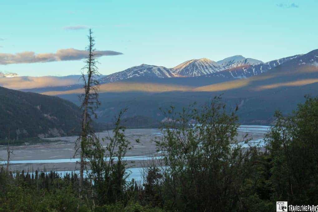
This is worth the short stop just to see the vast expanse of the river. Observing the glacial river from this vantage point, we could see the intricate network of river channels and braids. Unlike the rivers in the Kenai, the glacial silt makes these rivers brown. The river lies between the Chugach Mountains to the south and the Wrangell Mountains to the north. The river’s waters originate 75-mile east of this point at the Bagley Icefield, descending towards the Copper River.

Strelna and Silver Lakes (MM10-11) An Opportunity to Fish
The Alaska Department of Fish and Game stocks both lakes with rainbow trout. Short trails provide easy access to both lakes. As avid anglers, we spent an hour trying our luck at catching trout. Both areas gave us a tranquil, scenic setting. The natural beauty of this pristine wilderness makes it ideal for wildlife viewing. We had our first moose sighting of the day here. There were trumpeter swans feeding in the shallow waters on the opposite side of the lake.

Kuskulana Bridge (MM 17) Out of the Ordinary Experience
The Kuskalana Bridge is a remarkable example of engineering from the early 20th century. Established on the National Register of Historic Places, this single, majestic arch was built in 1910. It was part of the Copper River and Northwestern Railway. We found it to be an impressive steel truss bridge that stands a height of 238 feet above the river. It spans a frighting distance of 525 feet above the sheer rock walls of a deep gorge. The bridge is incredibly narrow and requires careful driving. For those wishing to take in more of the natural surroundings, there is a restroom and interpretive kiosk at the wayside, as well as a catwalk under the bridge. We parked and explored the catwalk, taking pictures of the breathtaking views. Just remember, it’s a long way down.

Chokosna Lake/Lou’s Lake area (MM 25) Rare Gem
This stop gave us a chance to stretch our legs. Chokosna Lake/Lou’s Lake presents opportunities for fishing, with anglers catching fish such as trout, landlocked silver salmon, and Arctic grayling. The Chokosna River is a prime spawning habitat for salmon. The marshes here provide a unique opportunity to see moose. We lingered here, taking a break from the long day. It gave us the chance to appreciate the unspoiled beauty of the Alaskan landscape.

Gilahina Trestle (MM 29) Bridge to Nowhere
The Gilahina Trestle is an impressive wooden trestle bridge that stands at a height of approximately 90 feet above the river. It spans a distance of approximately 880 feet. In 1911, eight days were needed to construct this monumental trestle. They listed it on the National Register of Historic Places, recognizing its importance as a historic structure. This trestle comprises wooden beams and supports that form a series of elevated spans. In spite of the fact that it is no longer used for railroad transportation, it is still worth observing. The Gilahina Trestle serves as a reminder of Alaska’s rich industrial history and the challenges of constructing transportation infrastructure in the region’s rugged terrain. It is quite magnificent. We recommend taking a bit of time to check out a little cabin under the Gilahina trestle.

Crystalline Hills Trail (MM 34.5) Unparalleled Views of the Mountains
This easy 2.8 mile loop trail winds through dense boreal forest. Scrambling off the side trails on the prominent ridge, you get some excellent views of the Chitina River valley, Moose Lake, and the Chugach Mountains. Mosquitoes, tons of mosquitoes, use lots of insect repellent or a head net. Just before we finished our hike, I looked across the road to see a lynx disappearing into the woods. It put us in awe that we again caught a glimpse of these elusive predators. In Cooper Landing on the Kenai on our first trip to Alaska in 2012, we saw a lynx.

End of the scenic drive to McCarthy: The McCarthy Road Information Station (MM 59)
The Information Station serves as a visitor contact center, providing information, maps, and guidance for travelers. Road conditions, safety tips, and answers to frequently asked questions are posted on the board. At McCarthy Road Information Station, there is free day-use parking, but you will need to walk to 1-mile to the footbridge. Just a short distance down the road is the Glacier View Campground. For $10 a day, you can park near the footbridge at one of the ‘base camp’ parking lots. They also sell coffee and snacks inside the little kiosk building. There is a simple outhouse for visitor use.
Remember, McCarthy is a remote area with limited services, so it’s essential to plan your visit ahead of time, pack appropriately for the weather and activities, and check for any specific requirements or restrictions related to tours or access to certain areas.

Navigating from McCarthy to Kennicott: What are my options?
After crossing the footbridge, there is an information board with shuttle details/schedules. Two shuttles handled transportation. Copper Town Shuttle provides free transportation from the footbridge to McCarthy General Store, continuing into Kennicott. Shuttles leave McCarthy twice an hour. This shuttle leaves the McCarthy General Store for Kennicott Mines every hour on the half-hour. The last shuttle departs Kennicott Mines at 7 p.m. Always check the shuttle schedule with the driver, as times can change. The Blackburn Heritage Shuttle costs $5 each way and offers transportation services from the footbridge to McCarthy and Kennecott. This shuttle operates on an hourly schedule. Most tours and lodging facilities pick up at the footbridge. Check with your tour guide to confirm.

Things to Do and See in McCarthy, Alaska:
At the end of the McCarthy Road, you’ll find the charming town of McCarthy and the historic Kennecott Mines. Despite its remote location, McCarthy offers plenty of activities and sights to explore. Here are some things to do and see in McCarthy:
- Discover the local history and culture at the McCarthy Museum. The museum showcases exhibits that provide insights into the town’s early days, mining heritage, and the people who shaped the area. It’s small and does not take much time, a great opportunity to learn about the unique character of McCarthy.
- From easy walks to challenging backpacking routes, the surrounding wilderness offers incredible opportunities for outdoor adventure.
- Learn about the strange yet colorful characters of McCarthy such as Kate Kennedy (1882-1964) did it all, from the Yukon to Nome and finally McCarthy, Alaska, where she spent three decades providing a wide range of amenities to Kennecott miners. In the era of Prohibition, she served alcohol in a teapot. While maintaining a clean boarding house, making homemade whiskey, playing poker, and was most renown for her kindness.
- Wander the streets, visit the local galleries and shops: McCarthy is home to several galleries and shops that showcase the work of local artists and craftspeople, including jewelry, pottery, and textiles.

Exploring the Untamed Beauty: Unforgettable Adventures in McCarthy
At the end of the McCarthy Road, you’ll find the historic Kennicott Mines, which was once one of the richest copper mines in the world. The mine is now a prominent tourist destination and grants guided tours. Today we have booked a 9:30 AM tour. Taking a guided tour is one of the best ways to learn about the mining history and the fascinating stories of the people who lived and worked here.

In the vicinity of the Kennicott Mines, the Root Glacier is a popular hiking and glacier exploration spot. Guided tours are available to help visitors navigate the glacier safely. The Root Glacier trail leads you through remarkable landscapes, past waterfalls, and eventually to the edge of the glacier. St. Elias Alpine Guides schedules glacier walks and ice climbing adventures for those seeking a more immersive experience. We laced up our hiking boots, embarking on the 2.5 mile scenic trail to marvel at the blue ice.

If you’re up for some thrilling whitewater rafting adventures, you got to check out McCarthy River Tours & Outfitters! They’re all about heart-pumping fun on rivers like the Nizina and Kennicott. Get ready for an awesome ride and stunning scenery with these guys!
Another option, if you have the time and can afford the expense, hop aboard a flightseeing adventure with Wrangell Mountain Air. During the flight, you will witness jaw-dropping views of glaciers, majestic mountains, and untamed wilderness. It’s like seeing the park from a whole new level of awesome! Don’t miss out on this incredible experience!

The Wagon Road & Toe of the Kennicott Glacier Trail
The “toe” of a glacier refers to the lowermost part where the glacier ends. Once you reach this point, you can observe the impressive ice formations and feel the enormity of the glacier up close.
The hike begins with a section along the historic wagon road. They used this road during the early 1900s to transport copper ore from the Kennicott Mines to the nearby town of Cordova. The Wagon Road is an alternative route to the town of Kennicott. This road gave us access to the Kennicott Cemetery. However, our shuttle driver told us that the spur trail to the toe of the glacier was worth the trip. He told us to just sit and listen to the sound of the calving ice.

We followed the road from the museum for 1000 feet. Look for a small red sign marked with “toe of the glacier.” If you miss the spur to the Wagon Road trail, there are several more along the road. Follow this to the wagon road. Overall, you will travel 1.5 miles one-way. On the Wagon Road, walk 3/4 of a mile. You’ll reach a fork. It is here that you will turn left towards the Kennicott Glacier’s “toe.” The trail wanders through the boreal forest. Remember to make lots of noise to avoid bears. At the end, it opens up to the glacial lake. The Unofficial trail continues along the glacial moraine.

Preserving the Past: Unraveling the Rich History of McCarthy, Alaska
The small town of McCarthy has a rich history with a laid-back, frontier feel. This historic mining town has many well-preserved buildings from the early 1900s. After our tour of the mine and our hike out to Root Glacier, we took a stroll down the main thoroughfare. I was admiring the rustic architecture of the buildings that housed the McCarthy Hardware Store and the Ma Johnson’s Hotel. If only the walls could talk. It was a unique opportunity to experience this charming off the grid town. This has to be the most dog-friendly place. We saw people traveling with their dogs on every road and trail we hit.

Discovering the Treasures of the McCarthy-Kennicott Historical Museum
When we visited the McCarthy-Kennicott Historical Museum, we did not expect to find engaging interactive displays. The exhibits delve into the rich history, exploring its humble beginnings and the sordid mining period. The meticulously curated artifacts are an authentic journey through time. This museum is small, and we enjoyed a staff member’s new puppy following us around the building. He told us the puppy has a habit of wandering down the road to the Potato climbing the tables eating patrons’ food.

Don’t hesitate to ask museum staff questions about the exhibits or any specific aspects of McCarthy’s history you’re interested in learning more about. We had a pleasant conversation with the gentleman about the early days of the town, specifically the fact that booze, gambling, and drugs were illegal in the copper mine town. It was interesting that bootlegging and brothels became a significant part of the local economy. Talking with the curator, his stories shed light on the remarkable heritage of this close-knit community. Instead of taking the shuttle to the footbridge, we walked back as the grey skies cleared to reveal the sun, making for a beautiful, warm afternoon.

Embrace Rustic Comfort: Best Accommodation Options in McCarthy, Alaska
McCarthy has limited accommodation options due to its secluded location. Yet, they offer travelers who want to experience the wilderness an exclusive but rustic experience. In peak tourist seasons, it is crucial to book your accommodation well in advance. The following are some of McCarthy’s most convenient accommodations:
- Ma Johnson’s Hotel: You’ll find this historic hotel in the heart of McCarthy. Rooms are comfortable and the atmosphere is cozy. In addition to the hotel’s restaurant, it offers a saloon where guests can relax and partake in alcoholic beverages.
- McCarthy Lodge The McCarthy Lodge offers both rooms and cabins for accommodation, just outside of downtown McCarthy. Guests can enjoy Alaskan cuisine and drinks at the lodge’s restaurant or bar.
- Blackburn Cabins: I liked that these little log cabins are on the Wagon Road, close to Kennicott Glacier. The cabins have good views of the mountains and easy walking distance to McCarthy. Cabins come with kitchenettes. Additionally, community shower facilities provide for a comfortable stay.
- The Kennicott Glacier Lodge: In the heart of Kennicott, these comfortable rooms have breathtaking views of the surrounding mountains and the Kennicott glacier. You can enjoy a drink and gourmet food at the lodge’s restaurant and bar.

Discover Remarkable Dining Options in McCarthy, Alaska
In McCarthy, you can chow down with locals and fellow travelers at some awesome local joints. Whether you’re craving a bite or in the mood for some liquid refreshment, you’ll find a few cool spots to hit up. You can grab a tasty meal at one of the local eateries or swing by the Golden Saloon for a drink. Here are a few options to check out:
- Guests at The Potato can choose from a variety of toppings for their baked potatoes. It is a popular spot among locals and visitors alike. We loved it! The fries are to die for.
- The Golden Saloon: Classic American fare, including hamburgers, sandwiches, and salads, is served at this historic bar and restaurant. We saw they had a wonderful selection of beer and cocktails.
- Meatza Wagon: Are you looking for world-famous tacos? You need look no further than this locally owned & operated food truck. Our lunch was delicious! All made with simple, and prepared with fresh local ingredients.
- Ma Johnson’s Hotel: Home-cooked meals are served at Ma Johnson’s Hotel. Among the family style dishes, they serve fried chicken, meatloaf, alongside scratch mashed potatoes.

Final Thoughts: Rare Opportunities on the Stunning McCarthy Road in Wrangell St Elias
The McCarthy Road in Wrangell-St. Elias National Park and Preserve offers rare opportunities to experience the stunning beauty of the region. It follows the path of the historic Copper River and Northwestern Railway, which played a vital role in Alaska’s mining history. As you drive, you’ll pass remnants of old railway infrastructure, including trestles and railroad cuts, offering a glimpse into the past and the challenges faced by early settlers, prospectors and miners.
Our journey took us through some of the most pristine wilderness in Alaska. Breathtaking opportunities to enjoy the natural beauty surround this remote and rugged park. Here on this occasion, we explored historic sites, experienced walking on a glacier, and just simply immersed ourselves in this beauty of this splendid place.
Have you driven the McCarthy road? What was your experience? What inspires you to explore and enjoy Wrangell-St Elias?